Better together: zoning (reform) and smart growth
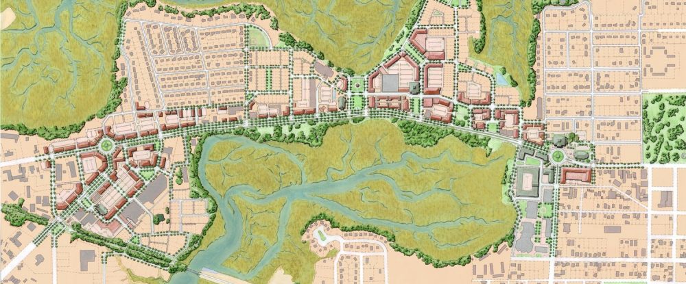
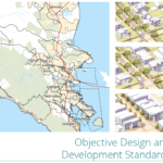
Illustrative master plan for the form-based code in Beaufort, SC (Image: Dover, Kohl & Partners)
Smart Growth America (SGA) continually pursues new angles to broaden its ability to create strong communities. By adding the Form-Based Codes Institute (FBCI) to its growing arsenal of programs, SGA is now bringing more comprehensive assistance to communities by addressing the regulatory framework that often limits smart growth—the zoning code.
Whether your community is attempting to revitalize a neglected downtown, pursuing Complete Streets, or trying to foster better transit-oriented development (TOD), it’s likely that conventional zoning codes are one of the barriers to success. While form-based codes are not a silver bullet or necessary in all circumstances, many communities find that zoning reform is essential to managing their growth and change in an intentional way.
By bringing the Form-Based Codes Institute under the Smart Growth America umbrella, SGA is now able to bake zoning considerations into all of our work and offer more complete assistance to local communities that are trying to change how they revitalize, grow, or develop.
As it has for years, the Form-Based Codes Institute continues to offer a comprehensive three-course series that equips local land use leaders and staff with the skills needed to understand, adopt, and implement an effective form-based code. The fall courses are coming up soon and you can register now.
For people or communities that need more tailored assistance, FBCI’s technical assistance program, Codes for Communities, is available to help city leaders update problematic codes or draft a state-of-the-art form-based code to ensure that their zoning supports the kind of human-scale communities they desire.
Here are a few examples of what this new layer of expertise has allowed SGA to accomplish:
Zoning review for a better Complete Streets policy in Maui
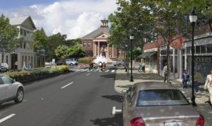
Rendering of a Complete Street in Hawaii (image: Honolulu.gov)
In 2009, the State of Hawaii passed a law requiring county transportation departments to adopt Complete Street policies to create safe streets that are accessible to all users, including people walking and biking, motorists, and transit riders of all ages and abilities. The National Complete Streets Coalition—another program of Smart Growth America—has played a leading role in expanding the popularity and effectiveness of Complete Streets nationwide.
But when Maui County adopted such a policy in 2012, it fell victim to a common problem—the policy did not override age-old restraints embedded in the county’s zoning code. Among other elements, Complete Street policies emphasize the importance of street design but often times, it’s the local ordinances that dictate what’s actually possible: the layout of street networks, how land can be used, the quantity and character of open space. So this spring, the county asked for code review from FBCI and SGA as part of FBCI’s Codes for Communities program.
Some of the recommended reforms included:
- Do away with dead-end streets and cul-de-sacs. Dead ends, cul-de-sacs, and the twisty, disconnected street grids they produce encourage and even necessitate more car trips, crippling Maui’s vision for more multi-modal transportation. A more walkable street network with sidewalks and slower speeds should be a priority. Using a grid pattern—coupled with regulations to support a mix of land uses—would promote a safe and highly accessible environment.
- Put wide lanes on a road diet. Hawaii’s Highway Standards mandate wide lanes that encourage speeding. Narrower lanes encourage slower speeds that are safer for people walking or biking and open more space available for bikes, wider sidewalks, or transit lanes.
- Focus on people first. Maui’s streets reflected the prevailing design practice in the U.S.—cars first with everything else as an afterthought. FBCI code reviewers encouraged the county to consider people walking and cycling first by creating wider shoulders or adding protected bicycle lanes and off-road, multi-use paths for example.
- Share parking lots and driveways. Maui’s zoning permitted exclusive parking lots with sporadic driveway entrances. Requiring more mixed use and aligning driveways with shared and connected parking lots would improve traffic flow and crash prevention.
- Reduce car trips with mixed-use development: Mixed-use districts—places with a mix of retail, residential, office and light industrial space, parks and plazas, and other uses—are becoming increasingly important as Maui continues to grow. Zoning for the creation of these multifunctional, walkable areas could lead to a 35 to 50 percent reduction in traffic.
- Retain rural character: A detailed county thoroughfare plan with narrow roadways, a network of off-street, multi-use paths, and additional landscaping was proposed to improve safety and ensure rural character was not lost.
This code review illustrates how crucial zoning is to producing an effective Complete Streets policy. With both the National Complete Streets Coalition and FBCI under one roof, SGA is able to better offer a multi-layered approach that includes some degree of zoning reform.
Zoning review for a transit-oriented Omaha
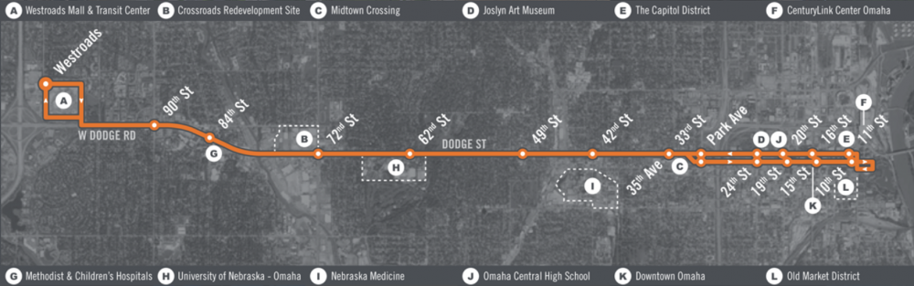
The future ORBT route in Omaha, NE (Image: ORBT)
SGA’s transit-oriented development (TOD) technical assistance program supports the efforts of communities across the country to build compact, mixed-use, equitable development around transit stops and stations. To be successful, careful attention and adjustments to land-use regulations and roadway design are important. A zoning makeover can make all the difference when trying to concentrate new housing and other development near transit.
Omaha, NE received TOD technical assistance from SGA in 2017 to maximize development potential along the Dodge Street bus rapid transit (BRT) corridor. SGA realized that this couldn’t be done without addressing the city’s zoning, especially within a quarter-mile of the corridor. FBCI completed the assistance with an in-depth review of Omaha’s zoning code and its impact on TOD. Specific recommendations to support a successful forthcoming transit corridor include:
- Develop new mixed-use TOD districts. The city’s comprehensive plan (which guides long-term development) calls for transit-oriented development. FBCI recommended two new, mixed-use zones at the district level—rather than on a parcel-by-parcel basis—to ensure coherent, walkable development along the transit corridor.
- Mix it up with higher density: If Omaha is serious about transit, it has to be serious about density. Code reviewers addressed a number of zones adjacent to BRT stations with a particular focus on urban form. By using form-based standards—and requiring taller buildings and sidewalk abutments—Omaha would move away from the spaced-out suburban character and instead shape the built environment for happier pedestrians and appropriately scaled buildings.
- Create shorter blocks. The tightly knit, TOD-friendly street grid around the BRT corridor should extend beyond just a few blocks. This will help ensure future development is also compact and pedestrian friendly.
- Consider street design standards around station areas. A handful of code amendments with street design standards would complement the Complete Streets policy in the city’s comprehensive plan and create appropriate streets around the transit corridor.
- Or… work within the existing regulatory framework. Code reviewers acknowledge that adopting new zoning districts can be difficult to orchestrate. They presented plausible alterations that could be made to the existing zoning code to try and realize some of the same effects, as an interim step.
Like many places, Omaha needed to consider how its zoning limits corridor design, pedestrian access, multiple uses, and development density. In situations like this, FBCI’s code review expertise can help make these elements a reality.
Webinar for developing under a form-based code
FBCI co-hosted “Developing under a form-based code” with SGA’s LOCUS Developers and Local Leaders Council at the end of May. The webinar attracted nearly 500 people and drew on a well-experienced panel of city officials and developers to talk about how form-based codes can help communities manage their growth.
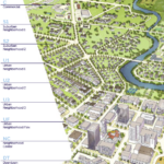
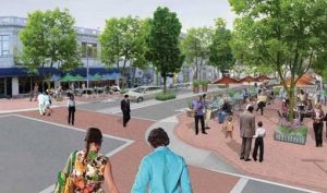
Rendering of potential redevelopment under the form-based code in Beaufort, SC (Image: Dover, Kohl & Partners)
Topics ranged from defining a form-based code to how it differs from a more conventional code to the reasons for adopting one. Projects in Beaufort, SC; Fort Worth, TX; and Conway, AR were detailed and called upon to discuss valuable lessons.
Local communities can’t fully address their challenges without a long look at the local zoning and land use codes that encourage (or discourage) certain types of development. By bringing FBCI into the larger ecosystem of Smart Growth America, SGA is able to offer more complete assistance to local communities who are eager for a better way to grow. Bringing FBCI to the table allows a wider audience to recognize that form-based codes are a vital tool for building high-quality places and realizing a community’s potential.
Don’t let a zoning ordinance stand between your and community and smart growth. Register for an upcoming FBCI course or consider our Codes for Communities program today!

 is back this spring!")


")