Form-Based Codes Institute at Smart Growth America

Form-Based Code

Like the Oscars, but for zoning

Like the Oscars, but for zoning

The Richard H. Driehaus Form-Based Code Award is back for its 12th year! If your community has adopted a form-based code that is promoting people-scaled development and a mix of uses, send us your code.

The Driehaus Award recognizes exemplary form-based codes that advance the practice of form-based zoning in both composition and implementation. Both newly-adopted and established codes showing positive built results are eligible.

Submissions are due by 5:00 p.m. Eastern Time on Friday, April 17. Details can be found on the Form-Based Codes Institute’s website, including the application form and instructions, previous winners, the 2020 Awards Jury, and eligibility requirements. For additional information, contact Tyler Quinn-Smith.

What makes an award-worthy form-based code?

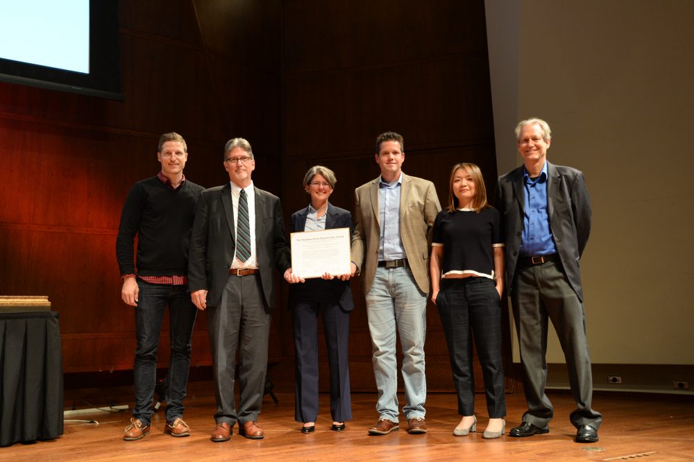
Last year’s award recognized three communities employing form-based codes to retain unique character and encourage predictable, walkable development that supports life’s daily needs. The downtown code for Lafayette, Louisiana received accolades from award jurors for its simplicity, superb graphics, and innovative parking policy. Buffalo, New York’s Green Code was praised for its complex city-wide application and streamlined, foolproof development process. And an honorable mention was given to the Canton, Connecticut for its effort to improve an auto-oriented suburban corridor. Learn more about the winners.

Form-based codes pose a significant advantage over auto-oriented, use-based zoning by focusing on the relationship between blocks, buildings, and public spaces. If properly written and implemented, form-based codes can promote human-scaled places that encourage a mix of uses and support walkability. Our jury of experts will examine the codes and consider the following criteria before choosing a winner:

  1. Will the code deliver a predictable street character (public space)?
  2. Is the code implementable and relatively easy to use?
  3. Does the code have relevant and distinguishing features that advance the practice?
  4. Will the code promote good urbanism (has it resulted in high-quality development activity)?

If you answered yes to any of the above, we strongly encourage you to submit a nomination.

Read More →

Read More →

New zoning makes New Rochelle’s vision a reality

New zoning makes New Rochelle’s vision a reality

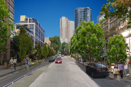
Rendering of New Rochelle’s Division Street under the downtown’s form-based code. (Image: Ideally New Rochelle, used with permission)

New Rochelle, New York struggled for years to stimulate catalytic development in it’s downtown. Now, this New York City suburb is emerging as a walkable, transit-oriented hub for residents to live, work, and play. A form-based code is making all the difference by spurring new development that is predictable, expedited, and responsive to community interests.

This post is the first in a series of case studies by the Form-Based Codes Institute on high-performing form-based codes and the exceptional development that has occurred as a result of their adoption.

New Rochelle, once a bustling downtown just 25 minutes by train from New York City’s Grand Central Station, declined in the 1990s and early 2000s. Promising attempts at revitalization failed to gain traction, in part because of an onerous process for reviewing and approving new developments. The city realized its existing zoning was standing in the way of its ambition to become an attractive place to live, work, and play—the basis of a redefined vision “New Rochelle, Ideally Yours.” So the city turned to a form-based code—the Downtown Overlay Zone (DOZ)—that is easy to understand and fast-tracks projects for approval, encouraging more development that the city wants.

A zoning change of this magnitude doesn’t come easy. New Rochelle’s Mayor Noam Bramson and Development Commissioner Luiz Aragon partnered with Renaissance Downtowns and RXR Realty (RDRXR) to kick-off a community-led effort to develop new zoning. In December 2015—less than a year after the start of the drafting process—the DOZ earned unanimous, bipartisan support from the city council, priming 12 million square feet of land for potential development.

Now, the same developers that found it almost impossible to get a project proposal approved in New Rochelle’s downtown are breaking ground. The DOZ is easy to interpret and project approvals generally take just 60 to 90 days. As a result, the city is growing in ways that support community interests—from student housing to art space—provide public amenities, and attract even more private sector investment.

NewRo Studios (ELD Properties and IMC Architecture) is a 73-unit project that will offer local artists below market rate live-work spaces, a rooftop performance area, an art gallery lobby, and 3,000 square feet of shared work space. (Image: Ideally New Rochelle, used with permission)

Engagement before planning

In developing the DOZ, city officials and RDRXR undertook a robust public engagement process to learn about residents’ perceptions of development and ensure that any plan was supported and led by the community. This multi-stage effort—which they called “crowdsourced placemaking“—began by asking people what they’d like their community to be and then worked backwards, understanding that the ultimate buildout had to provide benefits to the community, developers, and investors.

An online forum allowed residents to submit and vote on suggestions for public spaces and amenities they’d like to see. A downtown kiosk also allowed people to submit ideas in person. The most popular ideas were included in a community benefits program (more on that below) to incentivize developers to deliver the places and amenities community members wanted.

The ten most popular non-residential community chosen ideas generated on the NR Future platform. (Image: NR Future)

Beyond amenities, residents expressed an interest in transit-oriented development, mixed-use development, and greater walkability giving the city an opportunity to realign zoning—through the DOZ—and other regulations to meet the desires of both community and market.

“Crowdsourced placemaking ultimately allows for a co-creative process where you align community goals with the market and some really tremendous outcomes can occur.” — Brandon Palanker, Steering Committee member of the Form-Based Codes Institute and former president of Renaissance Downtowns

After nearly a year of intense community engagement and collaboration with the city, RDRXR produced a recommended action plan that included a detailed analysis of the information gathered through the crowdsourced placemaking process and recommended a form-based code for downtown.

Zoning: a means of shaping public space

New Rochelle took a form-based approach to zoning with the DOZ. The new code prioritizes human-scaled, walkable development envisioned by residents during the engagement process and is less prescriptive of each building’s specific function (anything from residential to light industrial is permitted across all zones). It directs development to the city’s urban core and downtown neighborhoods with context-based standards tied to the location and type of street a project is located on. Every part of downtown is carefully considered in the code and additional emphasis is placed on parcels identified as “terminating vistas” or “significant corners.” The DOZ contains six districts of varying intensity, depending on proximity to the New Rochelle Transit Center.

The code significantly shapes the environment where people stroll, walk to work, ride their bikes, or meet with friends—the space we call the public realm. It encourages pedestrian walkways to enhance accessibility in New Rochelle’s street network, and prohibits large “superblocks” that make walking less enjoyable. And thoughtful parking requirements incentivize developers to create shared, park-once facilities in the city core. The DOZ also focuses on private and public frontage in a way that keeps the pedestrian-level experience inviting and comfortable with minimal amounts of reflective windows, proper building placement and alignment, and streetscape features like sidewalk furniture and landscaping that create a sense of place. Some streets require storefronts and frequent openings to create “sticky” edges by breaking up long stretches of blank facades.

Regulating plan for the Downtown Overlay Zone form-based code. (Image: City of New Rochelle)

The DOZ also implements the community benefit program mentioned earlier that incentivizes developers to deliver the ideas and desires sought out most during the community engagement process. The program awards developersup to four additional floors if their project includes greater energy efficiency, attainable space for low-income artists, historic preservation, affordable housing, public space, entertainment venues, or specific community facilities.


And the DOZ has two elements that are particularly equitable and forward thinking. First, the new code requires that all projects provide 10 percent of the residential square footage for residents at 80 percent of area median income, on a permanent basis. Over 650 affordable units have already been approved or are under construction, with hundreds more expected by 2025. Second, the city completed a generic impact statement for projects in the overlay zone as a way to streamline New York’s traditionally onerous environmental review process.

New development

In just three years, New Rochelle has approved 31 projects—11 have broken ground and one is complete. And although many are six-story, mixed-use residential buildings or hotels, the city is beginning to receive more proposals for projects that rise 26 stories or higher. Here are a few that demonstrate the diversity of structures proposed across the city.

360 Huguenot: Developer RXR Realty earned four extra stories for this proposed 28-story mixed-use tower by including a 10,000 square-foot black-box theater and a replica of the historic Loew’s Theater marquee over the entrance as a community benefit bonus. Upper floors will include 280 residential units, 10 percent of which will be affordable to tenants earning 80 percent of the area median income.

Rendering of 360 Huguenot (RXR Realty and PS&S Design + Engineering). (Image: Ideally New Rochelle, used with permission).

Church/Division: This two-tower mixed-use project incorporates public open space between the two buildings—another community benefit bonus—which allows for connectivity throughout the site and ensures that the project is connected to the surrounding neighborhood.

The Lombardi was one of the first projects completed under New Rochelle’s DOZ. (Image: Karen & John Hessel, 101010NR.com, used with permission).

The Lombardi: One of the first projects completed under New Rochelle’s DOZ, the Lombardi is a six-story mixed use project that includes added retail space and 48 residential units—six of which are permanently affordable—just three blocks from the downtown transit center.

11 Garden: This mixed-use project includes a 219-unit residential component that’s entirely affordable (for 80 percent AMI) and a public plaza for all New Rochelle residents to enjoy. It will be “indistinguishable from luxury buildings” and a convenient three minute walk from the city’s train station.

2 Hamilton: This innovative, four-story, mixed-use renovation of and addition to a 90-year-old building includes 56 apartments atop original ground-floor retail space. The project was feasible due to the use of lightweight “mass timber” technology, in which cross-laminated timber is prefabricated and then quickly assembled on site like a Lego kit.

Existing conditions vs. proposed redevelopment for 2 Hamilton (Spiritos Properties and Organschi Architecture). (Image: Karen & John Hessel, 101010NR.com, used with permission).

The Downtown Overlay Zone is fulfilling expectations and transforming New Rochelle into a dynamic, walkable, mixed-use environment. The extensive engagement of local residents in defining the community amenities and respective development incentives was essential to this success. Their input provided the right formula to unleash market demand and create opportunities for new investment. Other communities with a deteriorated downtown and pent-up demand for walkable urban spaces can learn from these successful efforts.

At a glance: Project details

Downtown Overlay Zone

Project area: 275 acres

Permitted construction: 12+ million square-feet of new development: 2.4 million square-feet of prime office space, 1 million square-feet of retail, 6,370 housing units, and 1,200 hotel rooms 

Date adopted: December 2015

Mandatory/optional: Optional, the DOZ provides an alternative for property owners to redevelop or develop their land and buildings within the downtown. The DOZ prevails if there is a conflict between it and the underlying zoning.

Accompanying document: Recommended Action Plan 

Special features: 

  • Community benefit bonuses—developers can achieve additional height through:
    • Historic preservation, arts & cultural space, community facility, substantial amounts of public parking, green infrastructure such as LEED certification or a microgrid, pedestrian passage, open space, and/or affordable housing.
    • Or by making a payment to a community benefit fund. This money is used for improvements within the DOZ or for developing programs that facilitate job training, job placement services, and residential or business relocation assistance for properties in the DOZ.
  • Affordable housing requirement—all projects in the DOZ must permanently provide 10 percent of residential square footage at 80 percent of area median income or make a deposit into the city’s affordable housing fund. 
  • Fair share mitigation—per square-foot mitigation payments in lieu of an environmental impact statement to offset potential capital costs associated with the increased demand placed on certain community services and facilities. These mitigation measures are intended to compensate impacts on schools, wastewater, traffic, and emergency services.

Read More →

Read More →

From Desert to Oasis: Transformative FBC Will Help Turn a “Big Blank Piece of Sand” Into a Diverse, Attractive Community

From Desert to Oasis: Transformative FBC Will Help Turn a “Big Blank Piece of Sand” Into a Diverse, Attractive Community

At the Congress for the New Urbanism’s (CNU) Charter Awards Ceremony in Seattle on May 5, the Form-Based Codes Institute (FBCI) announced that Palm Desert, Calif., and Nashville, Tenn., had received the 2017 Driehaus Form-Based Codes Award for their implementation of innovative and effective codes. The Driehaus Form-Based Codes Award is sponsored by FBCI with the generous support of the Richard H. Driehaus Charitable Lead Trust. Nominated codes were critiqued by a four-member jury of peers.

Mention Palm Desert and many attractive features come to mind: mid-century modern architecture, luxury retail businesses, resort living and world-class golf, to name just a few. Walkable neighborhoods, an interconnected network of multi-modal streets and mixed-housing neighborhoods centers are not commonly associated with this widely known desert city, yet those are just what Palm Desert’s new general plan and University Neighborhood Specific Plan call for. The city’s leaders, with the support of the community, have decided that such places are the next missing pieces to add to its attractive repertoire, to diversify its lifestyle offerings as it matures in the 21st century.

Palm Desert was founded in 1945 in Riverside County as a 1,600-acre resort destination for celebrities and politicians on “the Grapefruit Highway” (Highway 111), connecting Los Angeles to Tucson and other destinations east. Its first neighborhood was marketed as a close-knit model of desert living where residents could walk or bike to local shops. Over the next 60 years, the city grew to cover more than 27 square miles based on the prevailing suburban development models of that time, introducing a grid of high-volume, high-speed six-lane arterial streets connecting – and separating – inward oriented housing tracts, and strip shopping centers. The majority of those housing developments were focused on retirement living, featuring golf courses and one-story houses, and big yards for enjoying outdoor desert living.

Looking to the future, city leaders initiated a strategic planning process in 2012, engaging the National Civic League to structure a community-based discussion of the city’s future. The process included a number of community surveys, dozens of community meetings, and a year and a half of work by a number of resident-led committees. The result was the “Envision Palm Desert” report, which identified top community priorities: attracting and retaining younger residents, balancing housing with new local jobs, and supporting higher education. Topping the list of strategies for achieving these goals was developing a “real city center” for Palm Desert and developing new walkable, bikeable, mixed-use and mixed-income neighborhoods both as part of the city center, and in a new university district anchored by a new California State University branch campus in North Palm Desert.

To put the strategic plan into action, the city retained a consultant team led by Raimi + Associates to update its general plan, including a plan to transform the old Highway 111 strip in the center of town to “Boulevard” 111. One block south of 111 is El Paseo, Palm Desert’s very walkable high-end shopping, arts and entertainment street, which was developed, ironically, in the 1970s at a time when so many other cities were letting their main streets decline and moving retail activity to suburban shopping malls. Through a series of workshops and design studies, a new vision for Boulevard 111 was agreed upon, transforming 111 from a “rip” – a physical barrier separating El Paseo from the neighborhoods and the civic center to the north – to a “zipper” that connects them. The team prepared the city center plan as a chapter of the new general plan, and new form-based zoning and public realm standards to implement it.

Based on the success of the city center work, Palm Desert retained the same consultant team – led this time by Sargent Town Planning (STP) – to prepare specific plan and form-based code for a 168-acre city-owned property near the new university campus. In the early work on the plan, the team noted that 200 acres of adjacent, previously planned and entitled – but currently unbuilt – conventional suburban housing tracts separated the city’s land from the campus, limiting connections to trails along arterial streets and overall circulation opportunities. Those previously approved tract maps were on the verge of expiring, and the property owners agreed to be part of the new plan in return for new entitlements permitting additional housing units on the condition that those units be delivered in a form consistent with the vision of the University Neighborhood Specific Plan.
University malls, promenades and other public spaces will contribute to the UNSP’s integrated community character.

The university neighborhoods, along with the planned campus expansion to the east and other adjacent development, comprise a university district of almost 1,000 acres at the north gateway to Palm Desert. Separating the neighborhood from the campus is Cook Street, a major north-south arterial corridor connecting from Interstate 10 to the city center several miles to the south. An important element of the plan is the transformation of Cook Street, which entailed converting the outer travel lanes to on-street parking and bike lanes, thereby calming the traffic and enabling new development to front Cook directly rather than huddling behind walls and parking lots. The result is a walkable mixed-use corridor that reconnects campus to the new university neighborhoods. The STP team engaged the university’s campus planning team and obtained the university’s enthusiastic support for this change. Additionally, a future Cook Street shuttle or bus rapid transit is planned to connect the university district to the city center to the south, along with a potential future passenger rail station.

To structure this new neighborhood, the STP team prepared a conceptual neighborhood plan organized by an interconnected network of complete streets throughout the plan area and connecting to the campus to the east. The focus of the plan is a new, mixed-use neighborhood center around a town green with local retail, restaurants, boutique office space, live-work opportunities, and a range of multi-family and attached single-family housing types. The neighborhoods are planned for a flexible mix of housing types – primarily single family attached and detached – organized around a network of small neighborhood parks and greens, connected by pedestrian-scaled neighborhood streets.

The code’s regulating plan applies three form-based zones to the university neighborhood planning area. The Neighborhood Low zone is intended to create a quiet neighborhood environment with single-family detached housing types on a range of lot sizes, and may include some single-family-attached and small multi-family “house-form” types that are compatible with houses in scale and character. The Neighborhood Medium zone includes those house-form types as well as courtyard housing and multi-family apartment buildings up to three stories in height, with building-scale standards. The Neighborhood Center zone is mixed in use, including ground floor retail, office and housing, allowing bot rental and ownership options. Finally, an Open Space zone reserves key locations for neighborhood and community-serving open spaces, such as the central town green, neighborhood parks of various shapes and sizes, and a large linear natural green space that fronts major arterials along the south and west borders of the planning area.

“In writing an FBC for a large area, which will take many years to complete, a core goal is creating long –term value that will accrue both to the community and to the master developer,” said John Baucke, president and CEO of New Urban Realty Advisors, Inc., who served as theSTP team’s development advisor, contributing a developer’s perspective to the project.

Because the district will be developed in phases over time by multiple builders and probably more than one master developer, and under changing market conditions – the code starts by defining “framework streets” that provide primary internal and external access and connectivity for the plan area, and organizes the planning area into a series of sub-areas. The exact alignment and design of the framework streets is somewhat flexible, as are the final sizes and configurations of blocks and lots, but the basic connectivity and design character are fixed by the plan.

The code starts with a section called “Subdivision Standards,” which walks the user through the process of finalizing the alignment and design of the framework streets, and organizing each sub-area into a walkable neighborhood area. Prior to any development within a sub-area, the code requires that the developer prepare a precise neighborhood plan for that area, defining with precision the layout of streets and blocks, which streets will be connected to adjoining sub-areas, which specific building types are intended, and the design and landscaping of all streets, parks, greens and alleys. Block sizes and shapes are flexible within parameters, with lot sizes and alleys, or no alleys, defined by intended building types and connectivity requirements.

The code provides a system of street typologies, to be assigned based on the intended function and environment of that street (e.g., an active mixed-use center, a neighborhood edge, a neighborhood connector, or a quiet neighborhood street). To further customize each street to its buildings, the code provides a range of public frontage types that describe the design configuration and character of the streetscape elements between the vehicular travel lanes and the buildings. These are calibrated to the intended ground floor use/activity of the adjacent private development, configuring on-street parking, street trees and landscape, street lighting and furnishings, and in some cases bike lanes. The result is intended to be an interconnected, safe, comfortable and attractive, multi-modal network of public spaces that provide unique, high-value addresses for buildings that front them.

A variety of public open spaces including edge greens, attached and detached neighborhood greens, pocket parks, paseos and rosewalks (pedestrian “streets” defined by building frontages), and alleys complete the public realm network. Alleys are required for narrow-lot, single-family and multi-family housing types, and at transitions from residential to commercial ground-floor use.

The code employs simple form-based development standard techniques for all buildings, focused on their size, placement and frontage. Frontages modulate the degree of privacy for ground floor spaces, ranging from low front-yard fences and climate-calibrated landscape, dooryards, terraces, porches stoops and commercial shopfronts and arcades. The code also includes standards for building scale and massing, regulating the expression of horizontal increments to ensure that the apparent scale of buildings within each zone and within each block fall within a harmonious range. Unlike many of the earlier codes by the firm and other West Coast practitioners, the standards do not explicitly include “building types”; rather, they are provided as part of an extensive design guidelines appendix, bound in a separate volume. The guidelines cover a wide range of topics including basic material and technique guidelines, landscape guidelines, and style-specific guidelines for a number of regionally significant architectural styles including Spanish colonial revival, mid-century modern and others.

The code requires that that the Precise Neighborhood Plan assign these elements street by street and block by block, for city review and approval as a unified package.

In preparing the development standards and design guidelines, a universal consideration was the nature of outdoor spaces at all scales. The integration of interior and exterior spaces has always been a defining characteristic of the “desert lifestyle,” including expansive views of neighborhood landscapes through the heat of the day, and the occupation of those spaces on winter days and long, warm evenings. Recent trends in market-based development types in Palm Desert were shifting directly from the very large lot, sprawling one-story homes to very small lot two-story homes with virtually no yard space. The University Neighborhood Plan proposed and intermediate possibility: relatively compact forms of two- and three- story housing that defines comfortable, pleasant, shady, wind-protected yard spaces well-connected to interior living spaces.

The code’s building siting and massing standards – and the building-types in the design guidelines, define such spaces that range from small side-yard patios to modest rear yards to semi-public dooryards, to courts, gardens and rosewalks shared by households in single family and multi-family compounds and buildings. And in the neighborhood center, siting and massing standards are provided to organize buildings around shared plazas, squares, and greens.

Although Palm Desert’s city council was wholeheartedly in favor of the STP’s focus on turning the university district into a connected, walkable community, the development team faced some significant challenges to some of its proposals at first. One such example was the re-imagining of Cook Street.

“Our goal was to transform Cook Street from just another aesthetically unremarkable highway taking drivers through town as quickly as possible, into an attractive, vibrant, business corridor,” David Sargent, president of Sargent Town Planning explained. “Finding ways to slow traffic down was essential to achieving this goal but it triggered push-back from some residents and officials, as you might expect. We were able to calm those objections by including some strategic triggers in the general plan. For example, the lane reductions wouldn’t be implemented until after the student population reached a certain level and a planned interchange has been built a half mile west of Cook Street to siphon off some of the traffic.”

As expected, finding developers willing to buy in to a community of this type requires patience, and it has. While the University Neighborhood Plan was in administrative draft form, a large, well-financed master developer expressed interest in buying and developing the northerly half of the planning area, hiring a land planner to lay out the neighborhoods. That initial concept plan was prepared without regard to the code, minimizing the public realm and connectivity and relegating “pedestrian connectivity” to a trail system running behind lots. The city indicated its support for the model proposed by the plan and code, and authorized the Sargent team to prepare a plan variation that met many of the developers housing type objectives in forms consistent with the plan, which generally was well-received.

“The developer hasn’t lost interest in building on the property and has taken what we did back to the drawing board. In fact, they’re talking about acquiring and developing the other 170-acre parcel, too,” said Ryan Stendell, the city’s community development director. He praised the team’s development advisor John Baucke and economist David Bergman, for helping the team to anticipate the developer’s concerns. “The master developer is moving forward because, looking at the property and the city’s plans for it from a market and financial perspective, it offers a strong potential to generate both short-term and long-term value,” said Baucke.

The jury that awarded Driehaus Form-Based Code Awards to Palm Desert, called it “an excellent example for regulating large-scale infill development to produce a walkable place,” and for providing “’a kit of parts’ for creating the fundamental urban form — addressing both the public realm and private development and achieving the ideal balance between predictability and flexibility. It creates a regulatory framework and process within which future detailed planning and development can take place. This code is elegantly designed, with clear and attractive images throughout and an appendix of beautifully illustrated design guidelines,” the jury declared.

Read More →

Read More →

Cincinnati Neighborhood Adopts Form-Based Code

Cincinnati Neighborhood Adopts Form-Based Code

Cincinnati Rendering

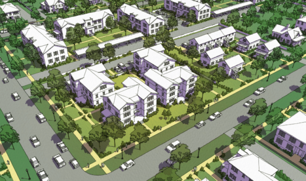
How Madisonville could look if future development follows a form-based approach

How to make a big city Form-Based Code? An important effort is underway in Cincinnati, where the city’s new code was adopted in May. Although citywide, the code depends on neighborhoods to take charge of their own development. It is intended to apply to 42 neighborhoods throughout the city, making it one of the largest applications of a FBC.

The Madisonville neighborhood, in northeast Cincinnati, is now the first to have its Regulating Plan approved. Madisonville community leaders see it as a framework for revitalization. Says community leader Sara Sheets, “The opportunity to develop a FBC for Madisonville caused the community to dream bigger and to expect better.”

The new regulating plan is helping the neighborhood to focus on developing a mixed-use business district, and community leaders will work with the city to interview developers in 2014. Opticos Design, Inc. helped city and neighborhood leaders to understand form-based codes, draft the citywide code and manage neighborhood charrettes to implement the new code in the neighborhoods.

Opticos has a 2-page article with photos describing the Cincinnati approach. An article on the Building Cincinnati website gives background on the city’s coding initiative. Form-based coding in Cincinnati was spearheaded by former mayor Roxanne Qualls, who is an advisor to FBCI.

Alan Mammoser AICP is Program Director for the Form-Based Codes Institute.

Read More →
Read More →
Market-Responsive Form-Based Codes

Market-Responsive Form-Based Codes

Originally published in Better! Cities & Towns, April-May 2013.

Richardson, Texas, an affluent inner-ring suburb of Dallas, and home to many telecommunications corporations, wants to remain attractive to employers in coming decades.

Key to that goal is becoming more walkable and connected to transit, qualities that many of today’s young and talented professionals are seeking. There are five Dallas Area Rapid Transit (DART) stations in Richardson, and unfortunately not one is in a walkable neighborhood. Such areas are in short supply in Richardson, which grew up entirely after World War II.

But a 100-acre previously undeveloped parcel adjacent to one of the stations will establish a new pattern: The site was rezoned recently for 3,200 residential units and up to 6,000 jobs. State Farm Insurance Company, which could have located anywhere in the region but was looking for a walkable urban center, chose this site.

As long as builders adhere to a new form-based code (FBC), no further public hearings are required. “We eliminated the risk of NIMBYism for a theoretical maximum buildout within a wide range of uses,” says Scott Polikov of Vialta Group, LLC, A Gateway Planning Company. “There’s nothing more market-responsive than that.”

A February report by real estate consultant Robert Charles Lesser & Co. (RCLCo), called “Market Pitfalls of Form-Based or Smart Codes,” criticized some FBCs for market inflexibility. Although the report cited no specific codes — and so was difficult to refute —it stung some new urban practitioners who take market demand seriously.

Bush Central

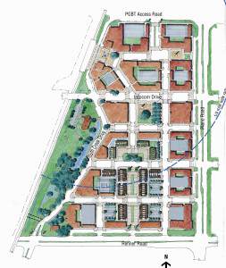
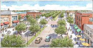
Bush Central TOD plan. Plan courtesy of Vialta Group, LLC, A Gateway Planning Company

Developers who wanted to reduce political and business risk initiated the code for the Bush Central TOD, as the Richardson site is called. The city gained assurances that the public realm would be built out in a way that is walkable and mixed-use, while the developers got flexibility and “by-right” entitlements, Polikov says. The master developersBush/75 Partners sold all the land, at a premium, within a year and vertical construction is underway at a rapid pace. Zale Corson Group is developing an urban multifamily project designed by JHP Architects, and KDC Development Company has purchased the remaining land for a mixed use, live-work-play project.

“We made the argument that this kind of development is required to keep attracting corporate citizens,” he says. “They wouldn’t be able to bring in the cool, echo-boomer development without a form-based code.”

City entitlements allowed higher densities without micromanaging uses, he adds. Within the 18 urban blocks that make up the site, uses are mostly flexible. On some streets, buildings must have first floors that accommodate retail — but other uses can occupy these areas if the market for retail lags.

“The form-based code allowed us to get a richer building envelope and enabled development to evolve over time,” Polikov says. “That’s a big story that the RCLCo criticism misses.”

The Bush Central TOD — named after a nearby highway that is named after the first President Bush — is laid out on a simple grid to be built out intensely. Public spaces are plentiful and a large natural park with trails along a creek will provide a connection to nature. The project will create a regionally significant urban center for the north side of Dallas.

Trinity Lakes

Across the metro area on the East Side of Fort Worth — a far less affluent part of the region — a form-based code was approved in December 2012 for a 175-acre transit-oriented development called Trinity Lakes.

This project is in the middle of suburban sprawl with a diverse Latino/white/African-American population. An existing commuter rail line between Dallas and Fort Worth borders the site, but a station needs to be built. A high-speed thoroughfare, Trinity Boulevard, bisects the site and must be transformed into a complete street.

Trinity Blvd Proposed

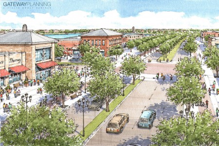
Trinity Boulevard in East Fort Worth is currently a highway but will serve as a town center. Rendering courtesy of Vialta Group, LLC, A Gateway Planning Company

The city, having adopted a FBC for an area adjacent to downtown, has experience with this type of regulation. The Trinity Lakes FBC was the first proposed by a private developer in Fort Worth. Residents of a large adjacent development, who have nothing but commercial strip retail nearby, were all for it. “They are sick of driving out of East Fort Worth for amenities that other neighborhoods have,” Polikov says.

Fort Worth is an area that gets a lot of development: In 2013, more than 4,000 residential building permits were issued in the city, about a third of them for multifamily units. But nothing like this has been attempted outside of the downtown core, let alone in a working-class neighborhood.

The city agreed to tax-increment financing (TIF) for $75 million in infrastructure to build the rail station, convert the highway into a multiuse boulevard, and pay for street, stormwater, and other improvements. The city and county will get a portion of new taxes for 20 years and then 100 percent thereafter.

The site links into the Trinity River Trail system in addition to the regional rail network.

The FBC is similar to the Richardson project. As long as the form-based aspects are adhered to, the developer has by-right entitlement to build out the project. “Form-based coding provided the vocabulary to communicate the benefits to neighbors, and it was the analytical vehicle to estimate a much higher tax-base capture,” Polikov says. Planned development in Trinity Lakes is estimated at $750 million, and it could transform this part of East Fort Worth.

High desert Savannah

Affluent or working class, the Dallas-Fort Worth metro area is a fast-growing region with 6.5 million people, and what works there may not work in other parts of the US. Clovis, New Mexico, with a population of 37,000 and located 90 miles from Lubbock, Texas, the nearest city of any size, could not be more different. Yet a market-based FBC could work there as well, Polikov says.

Cannon Air Force Base, a big part of the town’s economy, is expanding with a special operations command headquarters. Many officers and enlisted personnel have lived in Europe or big cities. A 640-acre project by local developers Jeff Watson and Sid Strebeck is designed to create the kind of environment that would appeal to the service men and women.

The project takes up an entire square mile section north of town, and the first neighborhood will be anchored by a middle school and park for which the developers are donating the land.

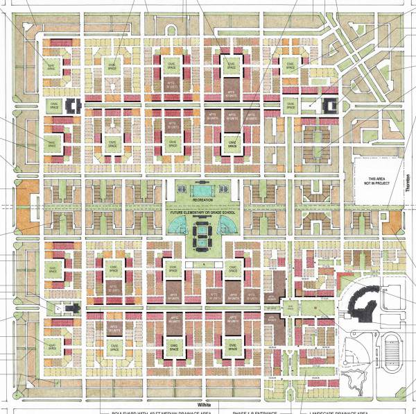
Saddlewood Plan Map

Saddlewood in Clovis, New Mexico, takes inspiration from Savannah, Georgia. Plan courtesy of Vialta Group, LLC, A Gateway Planning Company

Saddlewood is designed around 20 squares, much like Savannah, Georgia, and each square will be a module for development that includes a full range of housing types. The housing surrounding each square is, in effect, a phase of development that allows market flexibility, Polikov says. “We looked at historical places that allow variety but replication and we were influenced by Savannah,” he says. “There’s a predictable amount of infrastructure investment and we can build as much as we need,” he says.

Read More →
Read More →
Top