Form-Based Codes Institute at Smart Growth America

FBCs

From Desert to Oasis: Transformative FBC Will Help Turn a “Big Blank Piece of Sand” Into a Diverse, Attractive Community

From Desert to Oasis: Transformative FBC Will Help Turn a “Big Blank Piece of Sand” Into a Diverse, Attractive Community

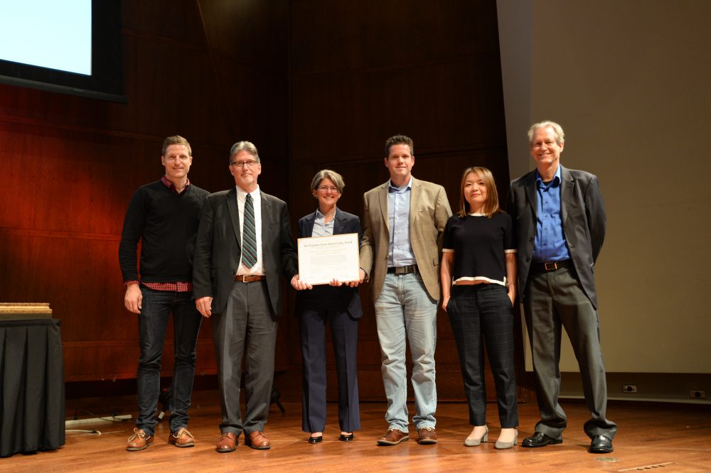
At the Congress for the New Urbanism’s (CNU) Charter Awards Ceremony in Seattle on May 5, the Form-Based Codes Institute (FBCI) announced that Palm Desert, Calif., and Nashville, Tenn., had received the 2017 Driehaus Form-Based Codes Award for their implementation of innovative and effective codes. The Driehaus Form-Based Codes Award is sponsored by FBCI with the generous support of the Richard H. Driehaus Charitable Lead Trust. Nominated codes were critiqued by a four-member jury of peers.

Mention Palm Desert and many attractive features come to mind: mid-century modern architecture, luxury retail businesses, resort living and world-class golf, to name just a few. Walkable neighborhoods, an interconnected network of multi-modal streets and mixed-housing neighborhoods centers are not commonly associated with this widely known desert city, yet those are just what Palm Desert’s new general plan and University Neighborhood Specific Plan call for. The city’s leaders, with the support of the community, have decided that such places are the next missing pieces to add to its attractive repertoire, to diversify its lifestyle offerings as it matures in the 21st century.

Palm Desert was founded in 1945 in Riverside County as a 1,600-acre resort destination for celebrities and politicians on “the Grapefruit Highway” (Highway 111), connecting Los Angeles to Tucson and other destinations east. Its first neighborhood was marketed as a close-knit model of desert living where residents could walk or bike to local shops. Over the next 60 years, the city grew to cover more than 27 square miles based on the prevailing suburban development models of that time, introducing a grid of high-volume, high-speed six-lane arterial streets connecting – and separating – inward oriented housing tracts, and strip shopping centers. The majority of those housing developments were focused on retirement living, featuring golf courses and one-story houses, and big yards for enjoying outdoor desert living.

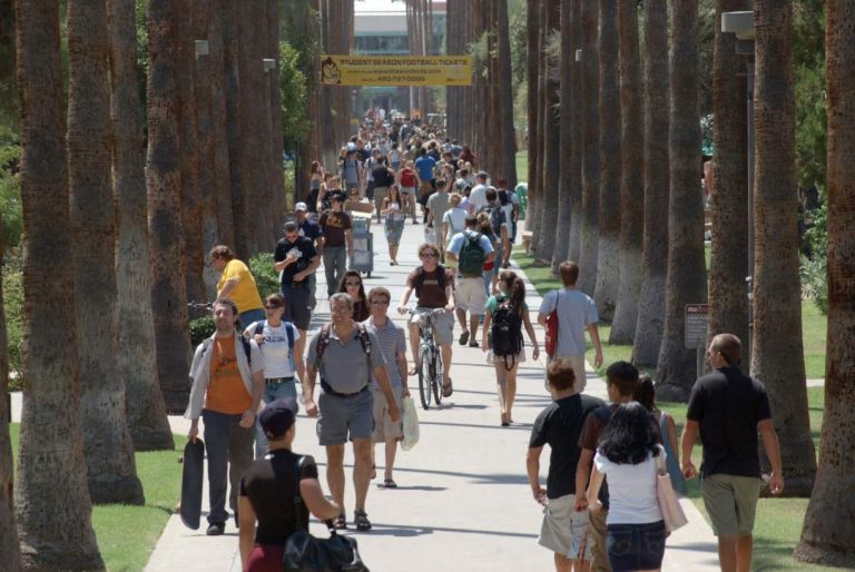
Looking to the future, city leaders initiated a strategic planning process in 2012, engaging the National Civic League to structure a community-based discussion of the city’s future. The process included a number of community surveys, dozens of community meetings, and a year and a half of work by a number of resident-led committees. The result was the “Envision Palm Desert” report, which identified top community priorities: attracting and retaining younger residents, balancing housing with new local jobs, and supporting higher education. Topping the list of strategies for achieving these goals was developing a “real city center” for Palm Desert and developing new walkable, bikeable, mixed-use and mixed-income neighborhoods both as part of the city center, and in a new university district anchored by a new California State University branch campus in North Palm Desert.

To put the strategic plan into action, the city retained a consultant team led by Raimi + Associates to update its general plan, including a plan to transform the old Highway 111 strip in the center of town to “Boulevard” 111. One block south of 111 is El Paseo, Palm Desert’s very walkable high-end shopping, arts and entertainment street, which was developed, ironically, in the 1970s at a time when so many other cities were letting their main streets decline and moving retail activity to suburban shopping malls. Through a series of workshops and design studies, a new vision for Boulevard 111 was agreed upon, transforming 111 from a “rip” – a physical barrier separating El Paseo from the neighborhoods and the civic center to the north – to a “zipper” that connects them. The team prepared the city center plan as a chapter of the new general plan, and new form-based zoning and public realm standards to implement it.

Based on the success of the city center work, Palm Desert retained the same consultant team – led this time by Sargent Town Planning (STP) – to prepare specific plan and form-based code for a 168-acre city-owned property near the new university campus. In the early work on the plan, the team noted that 200 acres of adjacent, previously planned and entitled – but currently unbuilt – conventional suburban housing tracts separated the city’s land from the campus, limiting connections to trails along arterial streets and overall circulation opportunities. Those previously approved tract maps were on the verge of expiring, and the property owners agreed to be part of the new plan in return for new entitlements permitting additional housing units on the condition that those units be delivered in a form consistent with the vision of the University Neighborhood Specific Plan.

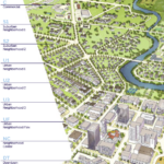
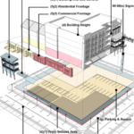
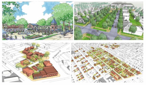
University malls, promenades and other public spaces will contribute to the UNSP’s integrated community character.

The university neighborhoods, along with the planned campus expansion to the east and other adjacent development, comprise a university district of almost 1,000 acres at the north gateway to Palm Desert. Separating the neighborhood from the campus is Cook Street, a major north-south arterial corridor connecting from Interstate 10 to the city center several miles to the south. An important element of the plan is the transformation of Cook Street, which entailed converting the outer travel lanes to on-street parking and bike lanes, thereby calming the traffic and enabling new development to front Cook directly rather than huddling behind walls and parking lots. The result is a walkable mixed-use corridor that reconnects campus to the new university neighborhoods. The STP team engaged the university’s campus planning team and obtained the university’s enthusiastic support for this change. Additionally, a future Cook Street shuttle or bus rapid transit is planned to connect the university district to the city center to the south, along with a potential future passenger rail station.

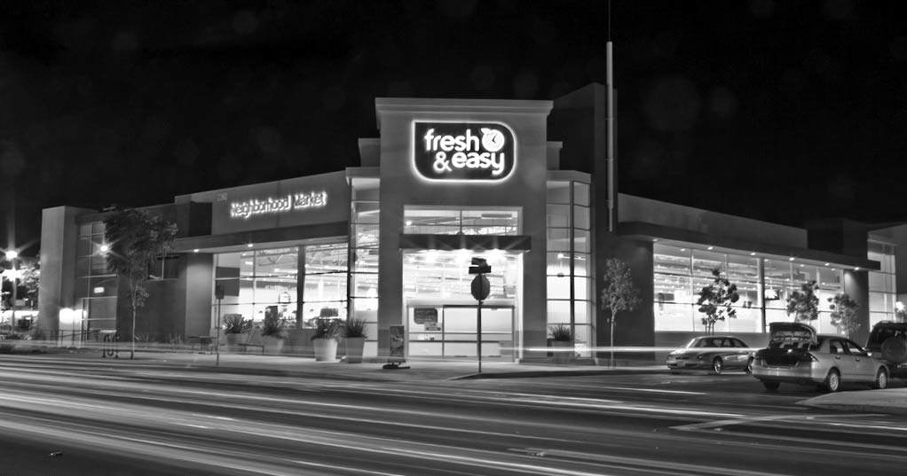
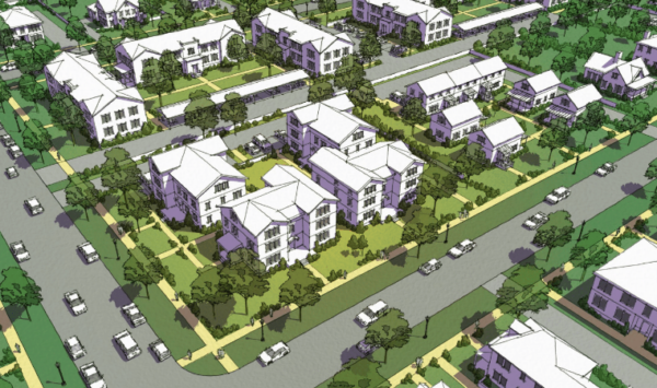
To structure this new neighborhood, the STP team prepared a conceptual neighborhood plan organized by an interconnected network of complete streets throughout the plan area and connecting to the campus to the east. The focus of the plan is a new, mixed-use neighborhood center around a town green with local retail, restaurants, boutique office space, live-work opportunities, and a range of multi-family and attached single-family housing types. The neighborhoods are planned for a flexible mix of housing types – primarily single family attached and detached – organized around a network of small neighborhood parks and greens, connected by pedestrian-scaled neighborhood streets.

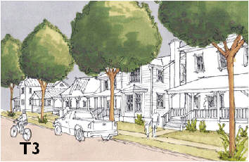
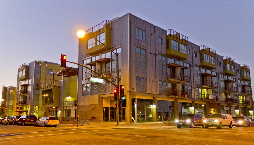
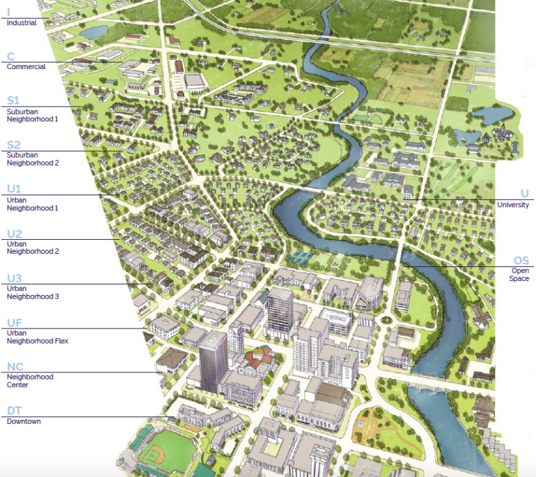
The code’s regulating plan applies three form-based zones to the university neighborhood planning area. The Neighborhood Low zone is intended to create a quiet neighborhood environment with single-family detached housing types on a range of lot sizes, and may include some single-family-attached and small multi-family “house-form” types that are compatible with houses in scale and character. The Neighborhood Medium zone includes those house-form types as well as courtyard housing and multi-family apartment buildings up to three stories in height, with building-scale standards. The Neighborhood Center zone is mixed in use, including ground floor retail, office and housing, allowing bot rental and ownership options. Finally, an Open Space zone reserves key locations for neighborhood and community-serving open spaces, such as the central town green, neighborhood parks of various shapes and sizes, and a large linear natural green space that fronts major arterials along the south and west borders of the planning area.

“In writing an FBC for a large area, which will take many years to complete, a core goal is creating long –term value that will accrue both to the community and to the master developer,” said John Baucke, president and CEO of New Urban Realty Advisors, Inc., who served as theSTP team’s development advisor, contributing a developer’s perspective to the project.

Because the district will be developed in phases over time by multiple builders and probably more than one master developer, and under changing market conditions – the code starts by defining “framework streets” that provide primary internal and external access and connectivity for the plan area, and organizes the planning area into a series of sub-areas. The exact alignment and design of the framework streets is somewhat flexible, as are the final sizes and configurations of blocks and lots, but the basic connectivity and design character are fixed by the plan.

The code starts with a section called “Subdivision Standards,” which walks the user through the process of finalizing the alignment and design of the framework streets, and organizing each sub-area into a walkable neighborhood area. Prior to any development within a sub-area, the code requires that the developer prepare a precise neighborhood plan for that area, defining with precision the layout of streets and blocks, which streets will be connected to adjoining sub-areas, which specific building types are intended, and the design and landscaping of all streets, parks, greens and alleys. Block sizes and shapes are flexible within parameters, with lot sizes and alleys, or no alleys, defined by intended building types and connectivity requirements.

The code provides a system of street typologies, to be assigned based on the intended function and environment of that street (e.g., an active mixed-use center, a neighborhood edge, a neighborhood connector, or a quiet neighborhood street). To further customize each street to its buildings, the code provides a range of public frontage types that describe the design configuration and character of the streetscape elements between the vehicular travel lanes and the buildings. These are calibrated to the intended ground floor use/activity of the adjacent private development, configuring on-street parking, street trees and landscape, street lighting and furnishings, and in some cases bike lanes. The result is intended to be an interconnected, safe, comfortable and attractive, multi-modal network of public spaces that provide unique, high-value addresses for buildings that front them.

A variety of public open spaces including edge greens, attached and detached neighborhood greens, pocket parks, paseos and rosewalks (pedestrian “streets” defined by building frontages), and alleys complete the public realm network. Alleys are required for narrow-lot, single-family and multi-family housing types, and at transitions from residential to commercial ground-floor use.

The code employs simple form-based development standard techniques for all buildings, focused on their size, placement and frontage. Frontages modulate the degree of privacy for ground floor spaces, ranging from low front-yard fences and climate-calibrated landscape, dooryards, terraces, porches stoops and commercial shopfronts and arcades. The code also includes standards for building scale and massing, regulating the expression of horizontal increments to ensure that the apparent scale of buildings within each zone and within each block fall within a harmonious range. Unlike many of the earlier codes by the firm and other West Coast practitioners, the standards do not explicitly include “building types”; rather, they are provided as part of an extensive design guidelines appendix, bound in a separate volume. The guidelines cover a wide range of topics including basic material and technique guidelines, landscape guidelines, and style-specific guidelines for a number of regionally significant architectural styles including Spanish colonial revival, mid-century modern and others.

The code requires that that the Precise Neighborhood Plan assign these elements street by street and block by block, for city review and approval as a unified package.

In preparing the development standards and design guidelines, a universal consideration was the nature of outdoor spaces at all scales. The integration of interior and exterior spaces has always been a defining characteristic of the “desert lifestyle,” including expansive views of neighborhood landscapes through the heat of the day, and the occupation of those spaces on winter days and long, warm evenings. Recent trends in market-based development types in Palm Desert were shifting directly from the very large lot, sprawling one-story homes to very small lot two-story homes with virtually no yard space. The University Neighborhood Plan proposed and intermediate possibility: relatively compact forms of two- and three- story housing that defines comfortable, pleasant, shady, wind-protected yard spaces well-connected to interior living spaces.

The code’s building siting and massing standards – and the building-types in the design guidelines, define such spaces that range from small side-yard patios to modest rear yards to semi-public dooryards, to courts, gardens and rosewalks shared by households in single family and multi-family compounds and buildings. And in the neighborhood center, siting and massing standards are provided to organize buildings around shared plazas, squares, and greens.

Although Palm Desert’s city council was wholeheartedly in favor of the STP’s focus on turning the university district into a connected, walkable community, the development team faced some significant challenges to some of its proposals at first. One such example was the re-imagining of Cook Street.

“Our goal was to transform Cook Street from just another aesthetically unremarkable highway taking drivers through town as quickly as possible, into an attractive, vibrant, business corridor,” David Sargent, president of Sargent Town Planning explained. “Finding ways to slow traffic down was essential to achieving this goal but it triggered push-back from some residents and officials, as you might expect. We were able to calm those objections by including some strategic triggers in the general plan. For example, the lane reductions wouldn’t be implemented until after the student population reached a certain level and a planned interchange has been built a half mile west of Cook Street to siphon off some of the traffic.”

As expected, finding developers willing to buy in to a community of this type requires patience, and it has. While the University Neighborhood Plan was in administrative draft form, a large, well-financed master developer expressed interest in buying and developing the northerly half of the planning area, hiring a land planner to lay out the neighborhoods. That initial concept plan was prepared without regard to the code, minimizing the public realm and connectivity and relegating “pedestrian connectivity” to a trail system running behind lots. The city indicated its support for the model proposed by the plan and code, and authorized the Sargent team to prepare a plan variation that met many of the developers housing type objectives in forms consistent with the plan, which generally was well-received.

“The developer hasn’t lost interest in building on the property and has taken what we did back to the drawing board. In fact, they’re talking about acquiring and developing the other 170-acre parcel, too,” said Ryan Stendell, the city’s community development director. He praised the team’s development advisor John Baucke and economist David Bergman, for helping the team to anticipate the developer’s concerns. “The master developer is moving forward because, looking at the property and the city’s plans for it from a market and financial perspective, it offers a strong potential to generate both short-term and long-term value,” said Baucke.

The jury that awarded Driehaus Form-Based Code Awards to Palm Desert, called it “an excellent example for regulating large-scale infill development to produce a walkable place,” and for providing “’a kit of parts’ for creating the fundamental urban form — addressing both the public realm and private development and achieving the ideal balance between predictability and flexibility. It creates a regulatory framework and process within which future detailed planning and development can take place. This code is elegantly designed, with clear and attractive images throughout and an appendix of beautifully illustrated design guidelines,” the jury declared.

Read More →

Read More →

The True Effectiveness of Form-Based Codes

The True Effectiveness of Form-Based Codes

In the words of Socrates, “By far the greatest and most admirable form of wisdom is that needed to plan and beautify cities and human communities.”

For those of us devoted to the arduous and complex task of building better places, an intriguing question was succinctly asked of the FBCI recently and it sparked a healthy debate amongst us.

How is a form-based code more effective than a conventional use-based code with form standards added to it?

We believe it is, but explaining exactly how requires us to be more precise.

But first, let’s take a step back in understanding how form-based codes (FBCs) came to be reintroduced into our planning lexicon. They are by no means new. The principal reason form-based codes were proposed, as an alternative to Euclidean codes, was one of absolute necessity in an attempt to provide a legal zoning framework that more consistently delivered walkable, mixed-use, compact communities of lasting value. New Urbanist plans were too often being derailed by, or just deemed too difficult to implement due to the convoluted zoning process. The existing codes simply no longer provided communities with what they collectively wanted and came to be viewed by planners, unhappy citizens and a growing cadre of elected officials as ineffective, complicated, unpredictable and costly. So change, and radical change no less, came about with a much greater emphasis on physical form, a higher quality public realm and character of place. FBCs have managed to achieve such desired physical outcomes more consistently and in ways that conventional codes have not.

While coders may argue that both FBCs and conventional codes can yield good designs, and indeed they can and have, I’d first rephrase the question to ask “which is more likely to yield a better place?” and to me, unequivocally, the former will. That is because FBC’s are principally designed to achieve a specific physical outcome with a primary focus on form and character of place and a secondary focus on uses and permitting. FBCs allow sustainable planning and infrastructure practices to shape communities. A good FBC organizes and regulates development by degree of urbanism, and manages to strike that delicate balance of being prescriptive enough to yield certain outcomes but not rigid enough to stifle creativity. An often-read critique accuses FBCs are being too prescriptive and rigid on aesthetics, yet most are silent on architectural style. Instead, I’d argue that FBCs provide more flexibility by assigning a different set of urban standards than use-based codes assign, yet allow for a much greater mix of uses within a building. I have yet to see a conventional use-based code, even with form-based standards attached to it, prioritize form within its proper context or provide the integral toolkit of components needed for place-making. Instead, we have seen the single-use, sprawl-inducing, auto-centric developments this typically yields.

The great places we love to visit have certain fundamental established elements that are not only measurable but that also provide the flexibility needed to evolve over time. None of them are strictly related to use, beyond facilitating mixed-uses. As an architect, I am well aware that zoning codes are no substitute for good architecture, but they can ensure a higher quality urbanism by establishing clear rules that shape the buildings, which is arguably more important. At their essence, FBCs more precisely regulate development to achieve a specific urban form and place particular emphasis on three critical issues that promote mixed-use, walkable environments. These are: 1) the relationship between a building and the street (a building’s frontage); 2) the public spaces; and 3) scale transitions between development intensities. FBCs do not ensure a great place any more than conventional codes preclude great places, but I believe they provide the better, reality-tested tools for crafting the vision.

So back to the original question posed above. The answers fall into two main categories:

1. FORM & TYPOLOGY

A key difference is that FBCs more precisely provide the essential range of tools required to ensure place-making in a manner that had become a lost or forgotten art. FBCs explicitly establish the relationship between the design of the public realm and private frontage and how the different components (such as frontage standards and building type standards) must interact together in order to achieve a community’s vision and shape their community accordingly. Such typologies are not as implicit in the more conventional codes.

(Images courtesy of City of Miami Planning Dept.)

Miami Before

Before the new form-based code
Miami, Fl

Miami After

After the new form-based code
Miami, FL

2. PROCESS & PLANNING

FBCs are often accompanied by master plans and/or regulating plans that tie form to pattern in ways that use-based codes do not. This makes FBCs more effective as they are often arrived at through a collaborative, community-based planning effort designed to settle on a vision plan.

Implementing FBCs are hard work and require great political will, support and commitment on behalf of elected officials and the community-at-large. However, once adopted, FBCs provide clarity of vision and allow for mixed-use and walkable environments by right, or with an easier approval process because a predictable physical outcome is much more likely and they have already received community support. Clear, user-friendly, graphic regulations also make the code easier to navigate and administer. Of course, conventional codes have also produced great urban spaces. However, they typically require greater effort through prolonged case-by case negotiations, which often prove to be too time-consuming, less fair, and unpredictable to be truly effective on a large scale. And that is why, even with the best of intentions of use-based codes, so many places fall short of the desired physical form. Conventional zoning codes introduced PUDs in an attempt to provide greater predictability of place, but they have yielded mixed results.

FBCs are by no means a panacea to all zoning woes. Our real mission is to enhance and create great urbanism by removing impediments in our current zoning codes. There are many ways to achieve that. All codes are unique to their place and context and I readily acknowledge there is a place for more conventional zoning or hybrid form-based zoning, depending on a host of factors, including a community’s desire to be preserved, allowed to gradually evolve or undergo substantial transformation.

Of course, the true measure of the success of both types of codes will ultimately be determined by the quality of development within a community, the work it took to achieve it, and how much it is loved, used, reused and respected by its residents over time.

The number of cities choosing to adopt form-based codes grew slowly at first, but is now growing exponentially as small and large, national and international municipalities alike begin to more forcefully shape their vision plans for more economic resilience, socially equity and environmental sustainability. According to one count, 455 form-based codes meet FBCI criteria, covering 39 million acres and 42 million people, generating billions of dollars of economic development and providing vital real-life testing of character-based land use regulations. Moreover, since 82% of these have been adopted since 2003, population density is expected to increase dramatically as development occurs under these form-based codes. (Source: http://www.placemakers.com/how-we-teach/codes-study/)

However, FBCs represent a mere 1% of codes currently under use. So much work remains to be done, yet I’d argue that FBCs are gaining traction when we begin to see conventional, use-based codes adapted with form standards attached to them. This too is an encouraging step in the right direction.

Read More →

Read More →

Form-Based Codes, Flagstaff & Education

Form-Based Codes, Flagstaff & Education

Flagstaff adopted a form-based code for the city’s downtown and neighboring historic districts in November 2011. As the city’s Zoning Code Administrator, I’ve helped to guide the code making since its inception, and I’ve enjoyed the process. I could tell you a lot about what I’ve learned along the way. In this post, I’ll just begin with a very basic consideration, a key ingredient to our success in Flagstaff. It is the essential importance of education from the very beginning to help city officials and all residents gain understanding of Smart Growth principles and FBCs.

Flagstaff-T5In fact we began with our staff, going back to 2006 when a developer pushed for a Traditional Neighborhood Development project, and we knew we needed updated zoning in place to support it. About that time, FBCI was launching its 3-course training series where five of our senior planning staff and the City Attorney attended. A year or so later, all city planning staff attended the three classes, while a few from Engineering took the introductory class.

The courses provided the foundation we needed, while our knowledge continued to grow as we developed a TND ordinance based on the SmartCode. We eventually expanded our efforts into a form-based code covering large areas of the city’s core and historic neighborhoods, in what became a parallel (optional) code with incentives for its use by developers. And we did this knowing that we faced natural resistance to new planning tools that most people know little about. Yet we did it without public opposition.

How? From the very beginning, we made a persistent and focused effort to educate the city’s elected and appointed officials (City Council and Planning and Zoning Commission), senior city staff including the city manager, and interested residents and stakeholders who would be actively involved in these codes’ adoption. The approach taken was simple, cost-effective, and not especially time consuming, but it did mean that residents and city officials were informed early in the process about new coding techniques and tools that were unfamiliar to them.

Flagstaff Open HouseWe began simply giving out literature: articles were shared with city officials, all pertinent city staff (including engineering, public works, and city attorney staff), and interested residents. Information gleaned from websites, online forums, and blog posts was also shared via memo or e-mail. We made sure we were not infringing on copyright requirements, and at all times cited authors and sources of information. Also, by hosting frequent informal community meetings, staff made presentations that not only conveyed information but helped to build a rapport and relationship with the community.

To our delight, we found that discussion of one particular subject would lead to a stimulating discussion on another. Staff delivered similar presentations to local stakeholder groups (realtors, contractors, chamber of commerce, etc.) as well as to local civic organizations. All in all, this simple and low-cost outreach and educational strategy proved extremely effective in Flagstaff, as it helped to build trust. Indeed, many who came to the meetings eventually became our strong allies as we worked to advance Smart Growth principles and FBCs.

Over time, community members began to understand the benefits of Smart Growth, TND, and FBCs. Perhaps more importantly, many realized that these tools and techniques could be applied in Flagstaff without infringing on individual property rights or mandating one development type over another, and that choices in lifestyle, housing type, commuter patterns, etc. would still prevail. At the time of adoption both the SmartCode-based TND ordinance and the parallel Form-Based Code saw very little public opposition or concern. Indeed a majority of speakers in public hearings expressed their support for these new codes.

So that’s a plug for education. I’ll write more about our technical challenges in writing and implementing these codes, in future posts appearing on this page.

Flagstaff-T3

Read More →

Read More →

Assessing Criticisms Of Form-Based Codes

Assessing Criticisms Of Form-Based Codes

Originally published in Better! Cities & Towns, April-May 2013.

Market share is a common metric for measuring success of a product. Since their resurrection in Seaside 30 years ago, roughly 300 form-based codes (FBCs) have been adopted. Many of these codes are for small specific areas, not the entire city. Overall, less than 0.2 percent of US cities have adopted FBCs. Why have we not gone to scale with these kinds of codes?

By their very nature FBCs faces many hurdles. Over the last century, we have separated zoning standards from physical planning, leaving out place-making. FBCs are now trying to make up for this all at once. The planner’s concern is we don’t have the capability to do it in-house and the money for consultants has dried up. We have to overcome the legacy of the planning system we have inherited and undergo a generational shift.

Bureaucracy and inertia make it difficult to escape from entrenched old ideas that are hard to change. While Euclidean zoning was born before the depression, it came to age in a rapidly growing post-war economy. FBCs are much more difficult to institute as they seek to replace an existing system in a much slower economy.

A mixed-use building designed in accordance with a form-based code in Ventura, California.

A mixed-use building designed in accordance with a form-based code in Ventura, California.

Critique of FBCs

One premise is that if people are attacking, you are probably making a difference. Change requires revolution, which tends to be rough and takes time. However, codes inherently are not perfect. The latest FBCs are better than the last one we wrote and we are constantly learning and making adjustments. It is in this spirit that we seek to understand some legitimate complaints against FBCs from the points of view of various stakeholders:

Designer’s perspective: FBCs are ideologically based and overly prescriptive. Some fear that a one-size-fits all, a FBC template may not address community context and character. Even if the community desires it, some codes are overly restrictive, controlling too much — leaving little room for discretion and creativity. Supporters of FBCs should decry such codes — they are just as bad as a loosely written code. Codes should balance predictable results with flexibility and creativity.

FBCs regulate most of the same elements designers must address under Euclidean codes, but with emphasis on the form of the public realm rather than compliance with abstract numerical ratios. Euclidean zoning offers token participation in the form of a public hearing at the end of the process. In contrast, FBCs are developed under an open participatory process that begins with the meticulous study of the existing physical context and character of a place. The most critical instrument of FBCs is the regulating plan, which unlike the land use zoning map, is based on development intensity and character, on a block-by-block and lot-by-lot basis.

Engineer’s perspective: Like Steve Job’s did at Apple, FBCs put good design before technical constraints thereby challenging the engineers to do their very best and not just rely on pre-ordained liberal safety nets such as the AASHTO Green Book, created by the professional organizations. “Transportation should be a means to an end, not the end in itself,” is a common adage at Nelson\Nygaard Associates, a transportation planning firm. The early and often participation from technical experts during the drafting of a FBC encourages the spirit of working together and breaking down silos.

Property owner’s perspective: Incremental redevelopment, the transition between old and new, can be awkward and painful. Requiring additions to viable uses and structures now deemed non-conforming by the new code to comply with a new system and standards, for example, is always a tough sell politically. Codes must be calibrated to accommodate transitional markets that can over time attract and evolve to the final desired market.

Planner’s perspective: Skepticism about success and training poses an uphill challenge. FBCs are seen as a tool developed by architects for planners — the two groups that were long separated by the universities and their differences reinforced by professional organizations. Further, the tool is perceived as largely consultant-driven, generating higher fees for more complex codes. Municipal planning and engineering staff are trained in Euclidean zoning with its restrictions and check lists. A FBC relies on the implementer being more of a generalist. The generalist has an appreciation for architecture, engineering, urban design, landscape architecture, project programming, and retail and commercial economics. Younger professional staff members are beginning to be exposed to this approach through education, seminars, and conferences and are generally more receptive to FBCs.

Planning educators perspective: Planning schools don’t find it necessary to teach physical planning as a core competency for a professional planner.  A few years ago the Planning Accreditation Board debated removing urban design as a core requirement for planners. In cases where planning schools are housed with architectural schools, the architects don’t teach FBCs because it constrains creative process of object buildings.

Professional organizations: Most members within professional organizations use Euclidean zoning so switching to FBC would be going against the norm. However we have tried the Euclidean framework for almost 100 years. It has failed to produce places of lasting value and is not likely to repair and restore the failing commercial corridors, office parks, shopping districts, and subdivisions. Codes are the number one tool for implementation and planners are in charge of the codes. Professional organizations can provide leadership in the field of regulatory reform.

Form-based grocery store in Ventura, California. Photo by Kaizer Rangwala.

Form-based grocery store in Ventura, California. Photo by Kaizer Rangwala.

Misconceptions

The failure to understand the purpose and technique of FBCs cause many to stand on the sidelines. Common misunderstandings include:

FBCs are too restrictive

FBCs’ focus on physical vision is perceived to force a narrow range of design options. However, both FBCs and conventional codes establish controls on development. FBCs emphasize standards that shape the collective public realm and offer a great deal of flexibility in the individual private realm. Standards for the public realm are based on community’s vision. Conversely, Euclidean codes control the use of the private realm with vague standards that fail to conceptualize a cohesive public realm. FBCs’ clear and precise standards, streamlined and predictable process, and predictable outcomes have opened development potential within numerous communities.

They ignore market realities

It is a widely known best practice to study the market potential before developing regulations. Market studies are more common with form-based than conventional Euclidean codes. In form-based coding, it is much easier to align the form, uses, building types, and infrastructure with market potential. Why? Because FBCs are an end-to-end integrated product that brings together the various disciplines of planning, design, economic development, engineering, and public safety early on to perform in unison. It becomes possible to analyze the community-supported vision from every point of view, to figure out the cost, and understand how various public and private partners can implement that vision. The results are therefore more predictable. At the same time, a lighter focus on use allows buildings to be nimble to the market.

A one-trick pony

A common misunderstanding is that FBC practitioners use the same playbook with one protocol, method, and template for every situation. Some critics find FBCs appropriate only for greenfield sites, and not appropriate in urban areas.

While the language of coding is common, practitioners employ different syntax and dialects. FBCs can be used to protect or transform an area. The applications range from the region to the neighborhood, integrated by a common thread to creating authentic, livable and lasting places.

Conceivably, FBCs could be written to facilitate sprawl. Similarly, the integrated platform of FBCs is better equipped to address the natural environment, affordable housing, and historic preservation. But if for some reason a community decides to not address these issues in their codes, this is not a weakness of the tool, but operator’s error.

Hybrid just sounds better

Hybrid implies the best of both worlds with more flexibility and less controversy. The term “hybrid code” confuses people as it has been used in a couple of ways. The first use of hybrid code is the method in which design guidelines or standards are added to a Euclidean zoning format. Despite the attempt to introduce design, the focus of such codes continues to be on control of density and uses.

This option leaves lots of room for subjective judgment when the codes are applied thereby compromising clarity, and predictable outcomes and processes. Avoiding tough issues for more flexibility fails to produce the results imagined in the vision and disillusions the public to question the efficacy of coding and planning.

In the second preferred option, also referred to as hybrid codes, FBCs are adopted for small areas within a city where walkable urbanism is desired. These FBCs are carefully integrated into the existing citywide Euclidean zoning platform. This option really does offer the best of both worlds.

What can we do to fix it?

We should ensure that the different professional organizations, media, conference organizers, seminar instructors, and the public get the facts correct. People will report what they hear, so it is important they have the correct information and easy access to the experts who understand form-based codes. Plenty of factual information exists and should be channeled to get proper media coverage.

FBC practitioners should refrain from overselling FBCs. It’s only a tool — not a panacea for the absence of good planning. Overselling hurts the product, as focus shifts to what it cannot do versus what it can do. People resist agenda-driven influences, if offered “fixes” they do not want or need. It’s more effective to influence than persuade. Our focus is to inspire lasting buy-in and commitment by painting a picture of a better place. In addition, practitioners must be prepared for lengthy follow-up sessions with implementing staff. This may include training sessions and assistance with project review.

Planners should reclaim their heritage in physical planning and design and lead this effort. Unlike conventional Euclidean codes, FBCs require multidisciplinary skill sets. Overcoming the usual disconnect between planning and design, large cities such as Nashville, Portland, Seattle, Boston, Los Angeles, Chattanooga, Charlotte and many others have urban design studios that are involved in design of spatial elements for short- and long-range planning projects. Smaller cities can bring attention to the design and coding of the public realm by bringing on a staff urban designer, landscape architect, or town architect.

Planning organizations and universities should offer urban design as a core course and the planner’s certification exam should test for competency with physical planning.

Conclusion

Market share is not the only metric for measuring success. Easy to use great products that have the ability to change people’s lives prevail in the long run. In 2010, Apple surpassed Microsoft as the world’s most valuable technology company. It had just 7 percent of the personal computer market but it boasted 35 percent of the operating profits. The market for PCs is shrinking while Macs are growing. As fuel prices soar over the next few decades, municipalities must be prepared to shift to a much more sustainable urban form. This can be accomplished with FBCs.

The good news is that the majority of these codes have been adopted in the past 10 years, so there is momentum. “As the economy recovers and more built results can be seen, this will likely cause an escalation of demand for FBCs,” says Carol Wyant Executive Director of the Form Based Code Institute. In recent years, a number of big cities have either adopted or are developing FBCs — this has raised the FBC profile and is inspiring others to follow suit.

Read More →

Read More →

Top