2016 Driehaus Award Winning FBCs Reflect the Unique Character, Aspirations of the Cities They Help to Reshape
Last June, FBCI presented the 2016 Driehaus Form-Based Code Award to Delray Beach, Fla., and Lacey, Wash., and gave honorable mention to Thompson’s Landing, Tenn., to acknowledge their development, adoption and implementation of innovative and effective form-based codes. This year’s honorees represent a diverse group of communities. One is a beach town that accommodates seasonal and year-round residents, another is a bedroom community for a major city and a large military base, and the third is a small rural community 30 miles from a highly popular national tourist destination. The form-based code that each city has devised reflects and addresses the challenges they face in preserving their unique character while preparing for growth.
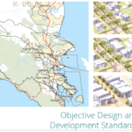
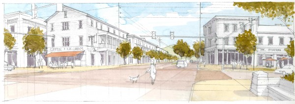
CDB Code and Architectural Guidelines for Delray Beach, FL
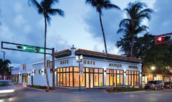
Delray Beach is a seasonal city with a population that grows by more than a third, to about 100,000 people, in winter. The city is divided from east to west by its main street, Atlantic Avenue, and from north to south by Interstate 95. The area west of I-95 is primarily suburban and accommodates mostly older residents. An affluent waterfront and beach environment thrives east of I-95 where most of the city’s African-American, Haitian and younger residents reside as well. The city’s downtown stretches west from the ocean to I-95. Atlantic Avenue, a pedestrian-friendly main street, intersects with an accessible and popular public beach.
Despite significant growth over the years, Delray Beach has retained its “unique beach town/small town vibe,” said Mayor Cary Glickstein. “I liken it to Mayberry by day and Manhattan by night.” The city’s goal is to grow economically while not losing its small-town charm. But by 2015, its 18-year-old master plan did not reflect the post-recession development surge the city was undergoing.
Under its new form-based code, the city’s central business district is designed to preserve the downtown area’s cultural and historic features while permitting economic growth. Mixed-use development is encouraged and residential development is permitted at higher densities in this area than anywhere else to foster compact, pedestrian-oriented growth and support downtown businesses. A portion of Atlantic Avenue has building height restrictions to help maintain the unique character of the City’s historic main street.
Seven architectural styles were deemed appropriate for the city’s downtown, based on historical precedent, climate and building scale: Florida Vernacular, Anglo-Caribbean, Mediterranean Revival, Classical Tradition, Art Deco, Masonry Modern and Main Street Vernacular. These style categories were intentionally kept to permit a broad range of detailing options, but “eclectic” interpretations that mix styles or apply historic details to modern forms are discouraged.
In the beach subdistrict, the city’s new master plan calls for redevelopment of existing buildings to place storefronts close to the street and parking in the rear. Where existing buildings are separated from pedestrian ways by wide landscaped areas, the addition of arcades and new building square footage to bring storefronts closer to the street is encouraged.
In the West Atlantic neighborhood subdistrict, priority is placed on preserving and enhancing existing neighborhoods while promoting a walkable commercial area along Atlantic Avenue with a mix of residential, commercial and civic activities, but the location of commercial establishments is limited to certain areas to preserve established residential neighborhoods.
In the railroad corridor subdistrict, development of light industry is permitted on downtown properties near the Florida East Coast Railway to provide local, downtown employment.
Although he is pleased with the city’s FBC, Glickstein acknowledges that it is impossible to develop one that address the competing priorities of a diverse range of stakeholders.
“Height and density restrictions are always a battle,” he said. “Residents want them; developers don’t. Parking is always a struggle as well. What’s too much versus what’s not enough for progressive downtowns with transportation alternatives? And architects objected to architectural restrictions as infringing on their creative abilities.”
Despite these objections, Glickstein believes Delray Beach’s FBC positions the city well to “grow older dynamically, competitively but also gracefully,”
The Driehaus Award jury praised Del Ray’s code and architectural guidelines, citing the code’s clear metrics, parking requirements and the requirement that buildings facing civic open spaces must contain active uses—which does not include parking lots, garages or storage areas.
“The required architectural guidelines embedded within the code elevate architectural expectation and ensure adherence to the city’s character while responding to climate and respecting history,” the jury noted.
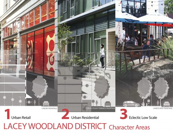
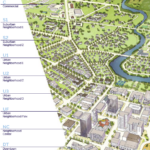
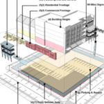
Hybrid Form-Based Code for Woodland District in Lacey, WA
Lacey, Wash., a suburb of Olympia, Tacoma and Joint Base Lewis-McChord, set a goal in 2000 to turn its Woodland District, which was characterized by suburban sprawl, into a thriving downtown area. By 2013, the district had many of the features needed to produce a thriving multi-use destination, including a university campus, grocery stores and retail, direct freeway access, transit, urban trails and parks, sidewalks and mature trees. A community college would establish a campus there in 2015 as well, and demand for housing has been growing. In short, as the authors of the city’s 2013 strategic plan put it, “the district has great bones” and citizens were ready to see it become a compact, pedestrian-friendly, mixed-use neighborhood.
However, as is typical of many suburban communities, blocks are large, the area has many single-use subdistricts with indirect walking routes and few direct routes connecting major destinations. A significant number of buildings in the district are partially or entirely empty, and state employment has declined.
As a result, the strategic plan calls for the development of a hybrid form-based code to guide the district’s transformation.
The code Lacey adopted is called a hybrid because it incorporates the administrative review processes and all other provisions of the city’s municipal code provisions. However, it also completely replaced the municipal code chapter for the Woodland District, explained Marcy McInelly, founder of Urbsworks, Inc., the urban design firm that served as primary author and integrator of the district’s form-based code.
The team found it necessary to make several adjustments in its approach toward making the suburban district more urban and walkable. In some outlying areas, where small business ownership prevails, for example, compliance with new requirements will be permitted to occur more gradually than in other areas, such the district’s center, to reflect the financial challenges some business owners will face in conforming to the FBC.
“Having an economic and real estate professional on the team was essential to ensure that the proportional compliance objectives could be met and be translated into regulations that were fair,” McInelly noted.
The team also anticipated installing landscape perimeter treatments to fill space where new buildings eventually will be built; as a result, regulations are designed to create an urban edge at the build-to line, McInelly added. Other requirements include visible entries to buildings, including those that are set back from the street or behind a parking lot, along with inviting pathways leading to them, to remove highway-like environments.
Among the training materials Urbsworks provided to help city staff navigate the code was a series of decision trees designed to illustrate both short- and long-term compliance and master plan requirements. These tools help applicants to answer questions in a logical order and guides them step by step through some of the code’s more complex elements, McInelly explained.
City officials and residents participated in developing the code, and stakeholders had more than a dozen opportunities to engage in the process, leading to a broadly supported downtown plan for the district. As a result, the city’s chamber of commerce plans to relocate its offices there, a popular local steakhouse will move to the district’s center, and a local developer who participated in the design charrette committed to building a residential tower in anticipation of the FBC’s adoption.
“Lacey’s code offers exemplary provisions for transitioning an auto-oriented suburban area into a walkable urban and transit-ready environment,” said Joseph Kohl, jury chair of the Driehaus Award. The code is “an excellent example of how land-use and form regulations can be successfully managed,” he added.
Land Development Ordinance to Reshape Thompson’s Station, Tenn.
Thompson’s Station is a small rural community with a population of approximately 3,000 about 30 miles south of Nashville, Tenn. The 16-square-mile incorporated area has a vast amount of open natural landscape and rolling hills, which the town seeks to preserve. By 2040, however, 40 percent of the 1 million people who are expected to settle in the Nashville metropolitan area are likely to wind up in Williamson County, where Thompson’s Station is located.
Unlike many form-based codes, which are incorporated as a chapter within a community’s land development ordinance, Thompson’s Station incorporated the FBC throughout its land development ordinance.
“The code is built in throughout the town’s zoning and subdivision regulations,” explained Susan Henderson, director of design at Placemakers, which helped to develop the FBC.
The code is designed to preserve open space “by allowing high-density development in strategic areas around town. It will allow us to grow our economic base without sacrificing what makes Thompson’s special,” explained Town Administrator Joe Cosentini.
The code calls for development next to urban areas to be built as villages or hamlets and integrated with the pattern of the existing community, along with trails and green corridors to connect urban areas. Mixed-use neighborhood development is preferred and should include a range of housing types to accommodate varied ages and income levels. The code also calls for civic, institutional and commercial activities to be embedded in neighborhoods, which also should have parks, town squares and playgrounds. Development also is expected to accommodate pedestrians and cyclists, and the code permits some vehicle parking spaces to be replaced with four-bicycle parking stations.
Zoning districts are divided into five types:
- Neighborhood high intensity: high-density, mixed-use buildings that accommodate retail, offices, town houses and apartments with a tight network of thoroughfares and buildings set close to sidewalks, which are wide and feature regularly spaced trees.
- Neighborhood medium intensity: a mix of neighborhood, commercial and service uses but primarily mixed-use residential (houses, townhouses, duplexes, small apartment buildings and live-work units) on medium-sized blocks. Setbacks and landscaping are variable.
- Neighborhood low intensity: low-density residential areas with some mixed use, consisting of home use and accessory buildings. Street and yard foliage is naturalistic and building setbacks are deep. Blocks may be large and thoroughfare networks are irregular.
- Rural: sparsely settled, open or cultivated land to include woodland, agricultural and pasture land. Buildings typically are farmhouses, agricultural buildings and single-family homes. Roads are rural and are not built to accommodate pedestrians.
- Natural: lands approximating or reverting to wilderness, including lands that are not suited to development due to typography, hydrology or vegetation. Construction of public parks is permitted but general development is not.
The code also identifies three sectors where specific levels of growth will be permitted:
- The controlled growth sector should consist of rural land, including hamlets and villages.
- The intended growth sector covers lands that can support substantial growth, based on their proximity to existing infrastructure that the town intends to develop into villages, workplaces and commercial centers.
- The targeted growth sector should encompass land adjacent to the historic center of Thompson’s Station and other areas where the town will protect the character of the historic buildings and intensify the intersection between a highway and a road to create a downtown.
The Driehaus Award jury saluted Thompson’s Station for developing its code, calling it “a well-prepared unified development ordinance that integrates new walkable urban districts within the existing pattern of use-based suburban standards.”

 is back this spring!")


")